| Citation: | NING B J,WANG N Z,JING L L,et al. The retrieval model of shore-based GNSS-R code altimetry[J]. Journal of Beijing University of Aeronautics and Astronautics,2025,51(4):1395-1403 (in Chinese) doi: 10.13700/j.bh.1001-5965.2023.0213

|
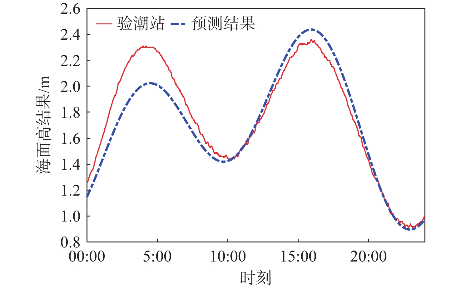
With the continuous innovation of GNSS technology, its application fields continue to expand. Because of its all-weather capabilities, low cost, and high spatiotemporal resolution, Global Navigation Satellite System-Reflectometry (GNSS-R) sea surface altimetry has many benefits in the field of ocean remote sensing. However, due to the limitation of GNSS chip width, the optimal accuracy of shore-based GNSS-R code-delay sea level measurements is only decimeter level, which makes it difficult to meet the accuracy requirements of Geodesy for sea surface height. In order to maximize the GNSS-R code-delay altimetry results, this research suggested using the Fourier series fitting method. To validate the suggested approach, GNSS-R code altimetry experiments were conducted in Weihai City, Shandong Province. The code-delay altimetry results of QZSS L2C signal, QZSS L5 signal and GPS L5 signal are respectively fitted and processed, and the inversion accuracy is calculated. When compared to the original altimetry findings, it is discovered that the RMSEs of the three original altimetry values with varying lengths have improved from 70-90 cm to 9-15 cm following Fourier series fitting. On this basis, the sea surface heights in the next 24 hours are predicted using the fitted Fourier series curve. Compared with the tide gauge data, the prediction results still maintain high accuracy, with RMSE of 13-18 cm and correlation a coefficient greater than 0.97. The above results indicate that the method proposed in this article can not only optimize the code-delay height measurement results and supplement the missing data, but also make high-precision predictions for future sea levels.

| [1] |
VALENCIA E, ZAVOROTNY V U, AKOS D M, et al. Using DDM asymmetry metrics for wind direction retrieval from GPS ocean-scattered signals in airborne experiments[J]. IEEE Transactions on Geoscience and Remote Sensing, 2013, 52(7): 3924-3936.
|
| [2] |
RUF C S, GLEASON S, MCKAGUE D S. Assessment of CYGNSS wind speed retrieval uncertainty[J]. IEEE Journal of Selected Topics in Applied Earth Observations and Remote Sensing, 2018, 12(1): 87-97.
|
| [3] |
RUF C S, BALASUBRAMANIAM R. Development of the CYGNSS geophysical model function for wind speed[J]. IEEE Journal of Selected Topics in Applied Earth Observations and Remote Sensing, 2018, 12(1): 66-77.
|
| [4] |
FOTI G, GOMMENGINGER C, JALES P, et al. Spaceborne GNSS reflectometry for ocean winds: first results from the UK TechDemoSat-1 mission[J]. Geophysical Research Letters, 2015, 42(13): 5435-5441.
|
| [5] |
CLARIZIA M P, RUF C S, JALES P, et al. Spaceborne GNSS-R minimum variance wind speed estimator[J]. IEEE Transactions on Geoscience and Remote Sensing, 2014, 52(11): 6829-6843. doi: 10.1109/TGRS.2014.2303831
|
| [6] |
GAO F, XU T H, MENG X Y, et al. A coastal experiment for GNSS-R code-level altimetry using BDS-3 new civil signals[J]. Remote Sensing, 2021, 13(7): 1378. doi: 10.3390/rs13071378
|
| [7] |
ZHANG G D, XU Z C, WANG F, et al. Evaluation and correction of elevation angle influence for coastal GNSS-R ocean altimetry[J]. Remote Sensing, 2021, 13(15): 2978. doi: 10.3390/rs13152978
|
| [8] |
CARRENO-LUENGO H, PARK H, CAMPS A, et al. Submeter ocean altimetry with GPS L1 C/a signal[C]// 2012 IEEE International Geoscience and Remote Sensing Symposium. Piscataway: IEEE Press, 2012: 7071-7074.
|
| [9] |
SOISUVARN S, JELENAK Z, SAID F, et al. The GNSS reflectometry response to the ocean surface winds and waves[J]. IEEE Journal of Selected Topics in Applied Earth Observations and Remote Sensing, 2016, 9(10): 4678-4699. doi: 10.1109/JSTARS.2016.2602703
|
| [10] |
RUFFINI G, SOULAT F, CAPARRINI M, et al. The Eddy Experiment: accurate GNSS-R ocean altimetry from low altitude aircraft[J]. Geophysical Research Letters, 2004, 31(12): 261-268.
|
| [11] |
吴军, 张波, 洪学宝, 等. 基于北斗卫星反射信号的海面溢油探测方法及试验[J]. 北京亚洲成人在线一二三四五六区学报, 2017, 43(1): 193-199.
WU J, ZHANG B, HONG X B, et al. Sea surface oil spill detection method using BeiDou satellite reflected signal and its experiment[J]. Journal of Beijing University of Aeronautics and Astronautics, 2017, 43(1): 193-199(in Chinese).
|
| [12] |
VALENCIA E, CAMPS A, RODRIGUEZ-ALVAREZ N, et al. Using GNSS-R imaging of the ocean surface for oil slick detection[J]. IEEE Journal of Selected Topics in Applied Earth Observations and Remote Sensing, 2012, 6(1): 217-223.
|
| [13] |
LI C, HUANG W M, GLEASON S. Dual antenna space-based GNSS-R ocean surface mapping: oil slick and tropical cyclone sensing[J]. IEEE Journal of Selected Topics in Applied Earth Observations and Remote Sensing, 2014, 8(1): 425-435.
|
| [14] |
ZHU Y C, TAO T Y, LI J Y, et al. Spaceborne GNSS-R for sea ice classification using machine learning classifiers[J]. Remote Sensing, 2021, 13(22): 4577. doi: 10.3390/rs13224577
|
| [15] |
ZHANG Y, MENG W T, GU Q M, et al. Detection of Bohai Bay Sea ice using GPS-reflected signals[J]. IEEE Journal of Selected Topics in Applied Earth Observations and Remote Sensing, 2014, 8(1): 39-46.
|
| [16] |
YAN Q Y, HUANG W M, MOLONEY C. Neural networks based sea ice detection and concentration retrieval from GNSS-R delay-Doppler maps[J]. IEEE Journal of Selected Topics in Applied Earth Observations and Remote Sensing, 2017, 10(8): 3789-3798. doi: 10.1109/JSTARS.2017.2689009
|
| [17] |
ALONSO-ARROYO A, ZAVOROTNY V U, CAMPS A. Sea ice detection using U. K. TDS-1 GNSS-R data[J]. IEEE Transactions on Geoscience and Remote Sensing, 2017, 55(9): 4989-5001. doi: 10.1109/TGRS.2017.2699122
|
| [18] |
MARTIN-NEIRA M. A passive reflectometry and interferometry system (PARIS): Application to ocean altimetry[J]. ESA Journal, 1993, 17(4): 331-355.
|
| [19] |
MARTIN-NEIRA M, CAPARRINI M, FONT-ROSSELLO J, et al. The PARIS concept: an experimental demonstration of sea surface altimetry using GPS reflected signals[J]. IEEE Transactions on Geoscience and Remote Sensing, 2001, 39(1): 142-150. doi: 10.1109/36.898676
|
| [20] |
TREUHAFT R N, LOWE S T, ZUFFADA C, et al. 2-cm GPS altimetry over crater lake[J]. Geophysical Research Letters, 2001, 28(23): 4343-4346. doi: 10.1029/2001GL013815
|
| [21] |
王鑫, 孙强, 张训械, 等. 中国首次岸基GNSS-R海洋遥感实验[J]. 科学通报, 2008, 53(5): 589-592. doi: 10.1360/csb2008-53-5-589
WANG X, SUN Q, ZHANG X X, et al. First China ocean reflection experiment using coastal GNSS-R[J]. Chinese Science Bulletin, 2008, 53(5): 589-592(in Chinese). doi: 10.1360/csb2008-53-5-589
|
| [22] |
白伟华, 孙越强, 朱光武, 等. 利用岸基GNSS-R 信号反演湖面高度[C]//第一届中国卫星导航学术年会, 2010: 496-502.
BAI W H, SUN Y Q, ZHU G W, et al. Lake surface height retrieve using coastal GNSS-R signals[C]//The first China Satellite Navigation Conference, 2010: 1646-1652(in Chinese).
|
| [23] |
ZHANG Y, TIAN L M, MENG W T, et al. Feasibility of code-level altimetry using coastal BeiDou reflection (BeiDou-R) setups[J]. IEEE Journal of Selected Topics in Applied Earth Observations and Remote Sensing, 2015, 8(8): 4130-4140. doi: 10.1109/JSTARS.2015.2446684
|
| [24] |
储倜, 贺凯飞, 高凡, 等. 基于QZSS L1信号的岸基GNSS-R码延迟海面测高[J]. 北京亚洲成人在线一二三四五六区学报, 2022, 48(4): 691-697.
CHU T, HE K F, GAO F, et al. Coastal GNSS-R ocean altimetry based on code delay of QZSS L1 signal[J], Journal of Beijing University of Aeronautics and Astronautics, 2022, 48(4): 691-697(in Chinese).
|
| [25] |
侯金华, 贺凯飞, 高凡, 等. 岸基BDS-R海面测高及其观测值加权方法[J]. 北京亚洲成人在线一二三四五六区学报, 2024, 50(3): 1015-1026.
HOU J H, HE K F, GAO F, et al. Shore-based BDS-R sea surface altimetry and weighting method of its observed values[J]. Journal of Beijing University of Aeronautics and Astronautics, 2024, 50(3): 1015-1026(in Chinese).
|
| [26] |
孟馨悦. GNSS-R实时软件接收机设计及其海陆应用[D]. 济南: 山东大学, 2022.
MENG X Y. Design of GNSS-R real-time software receiver and its land and sea application[D]. Jinan: Shandong University, 2022 (in Chinese).
|
| [27] |
贺匀峤. 高精度GNSS-R海面测高基带信号处理研究[D]. 济南: 山东大学, 2022.
HE Y Q. Research on baseband signal processing of high precision GNSS-R sea surface altimetry[D]. Jinan: Shandong University, 2022 (in Chinese).
|
| [28] |
WANG N Z, HE K F, GAO F, et al. Analysis of GNSS-R code-level altimetry using QZSS C/A, L1C, and BDS B1C signals and their combinations in a coastal experiment[J]. IEEE Journal of Selected Topics in Applied Earth Observations and Remote Sensing, 2023, 16: 4549-4564. doi: 10.1109/JSTARS.2023.3274570
|

Figures(8) / Tables(4)
Copyright © Journal of Beijing University of Aeronautics and Astronautics
Address: Editorial Department of Journal of Beijing University of Aeronautics and Astronautics, 37 Xueyuan Road, Haidian District, Beijing Post Code: 100191 Email: jbuaa@cqjj8.com
Supported by:
Beijing Renhe Information Technology Co., Ltd.


 DownLoad: