| Citation: | ZHANG Y,XIAO S,JIANG L F,et al. Significant wave height retrieval model of CYGNSS based on multivariate machine learning[J]. Journal of Beijing University of Aeronautics and Astronautics,2025,51(5):1503-1513 (in Chinese) doi: 10.13700/j.bh.1001-5965.2023.0265

|
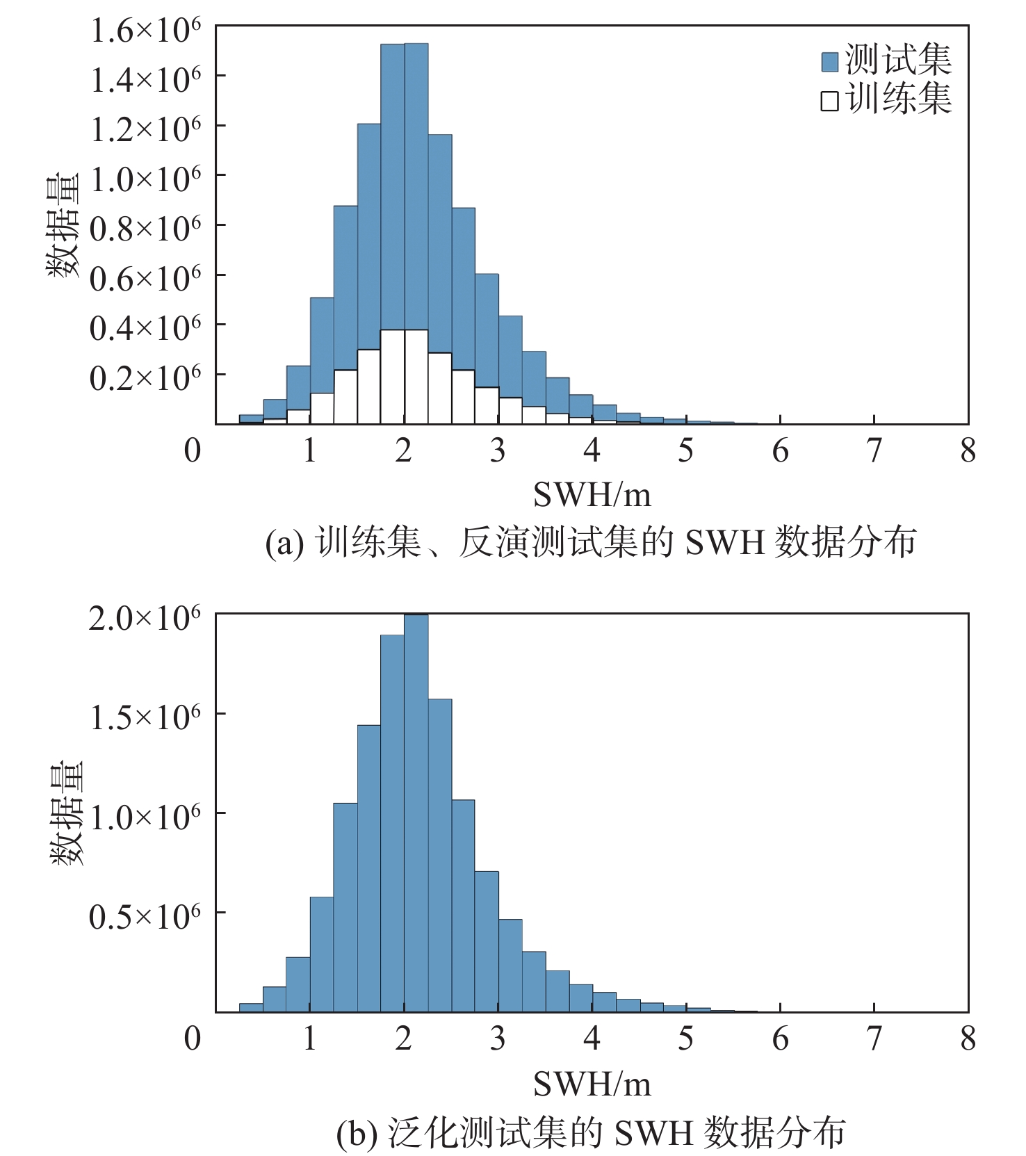
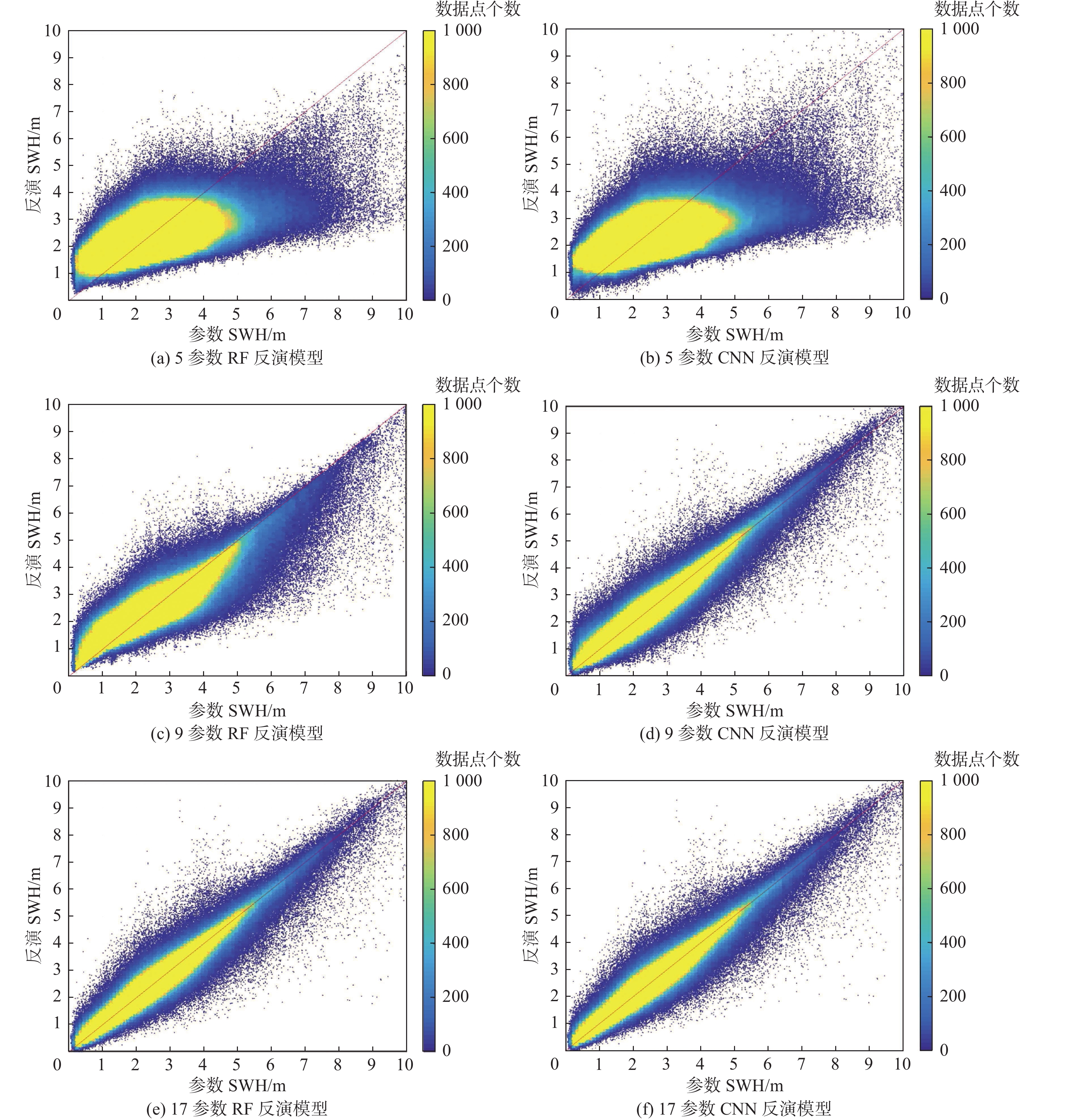
The cyclone global navigation satellite system (CYGNSS) provides high-quality global navigation satellite system reflectometry (GNSS-R) data that can be reliably used for the retrieval of significant wave height (SWH). Due to the high dynamic nature of CYGNSS, the received signal is easily affected by environmental factors, and the complexity of sea conditions makes it difficult for simple models to accurately retrieve SWH. To address the above issues, this article proposed an SWH retrieval model based on multivariate machine learning. According to the mechanism of wave formation and the analysis of the correlation between CYGNSS parameters and SWH, relevant parameters were selected, and three training schemes were designed, involving five parameters, nine parameters, and 17 parameters, respectively. Random forest (RF) and convolutional neural network (CNN) were used to train and verify the retrieval model, and the SWH retrieval results were compared with the reference values of the European Centre for Medium-Range Weather Forecasts (ECMWF). The best retrieval model among them was the 17-parameter CNN retrieval model, with root mean square error(RMSE)was 0.184 0 m and $ {R}^{2} $= 0.948 5. Compared with the 17-parameter CNN retrieval model, the 9-parameter CNN retrieval model reduced training time by 24% and has minimal accuracy loss. However, the 9-parameter retrieval model performed poorly in terms of generalization evaluation compared to the 17-parameter retrieval model. To improve the generalization ability of the model, wind speed was added as a parameter to the 17-parameter retrieval model, resulting in a 17 + 1-parameter generalization model. The best generalization model among them was the 17 + 1 parameter RF generalization model, with RMSE was 0.497 1 m and $ {R}^{2} $= 0.584 6. This effectively proves that the model proposed in this article has good potential in SWH retrieval.

| [1] |
FOTI G, GOMMENGINGER C, JALES P, et al. Spaceborne GNSS reflectometry for ocean winds: first results from the UK TechDemoSa-1 mission[J]. Geophysical Research Letters, 2020, 42: 5435-5441.
|
| [2] |
CLARIZIA M P, RUF C S. Wind speed retrieval algorithm for the cyclone global navigation satellite system (CYGNSS) mission[J]. IEEE Transactions on Geoscience and Remote Sensing, 2016, 54(8): 4419-4432. doi: 10.1109/TGRS.2016.2541343
|
| [3] |
ZHANG Y, CHEN X, MENG W T, et al. Wind direction retrieval using support vector machine from CYGNSS sea surface data[J]. Remote Sensing, 2021, 13(21): 4451. doi: 10.3390/rs13214451
|
| [4] |
CARDELLACH E, LI W Q, RIUS A, et al. First precise spaceborne sea surface altimetry with GNSS reflected signals[J]. IEEE Journal of Selected Topics in Applied Earth Observations and Remote Sensing, 2019, 13: 102-112.
|
| [5] |
LI W Q, CARDELLACH E, FABRA F, et al. Assessment of spaceborne GNSS-R ocean altimetry performance using CYGNSS mission raw data[J]. IEEE Transactions on Geoscience and Remote Sensing, 2020, 58(1): 238-250. doi: 10.1109/TGRS.2019.2936108
|
| [6] |
ZHANG Y, LI B B, TIAN L M, et al. Phase altimetry using reflected signals from BeiDou GEO satellites[J]. IEEE Geoscience and Remote Sensing Letters, 2016, 13(10): 1410-1414. doi: 10.1109/LGRS.2016.2578361
|
| [7] |
ZHANG Y, TIAN L M, MENG W T, et al. Feasibility of code-level altimetry using coastal BeiDou reflection (BeiDou-R) setups[J]. IEEE Journal of Selected Topics in Applied Earth Observations and Remote Sensing, 2015, 8(8): 4130-4140. doi: 10.1109/JSTARS.2015.2446684
|
| [8] |
ZHANG Y, HUANG S, HAN Y L, et al. Machine learning methods for spaceborne GNSS-R sea surface height measurement from TDS-1[J]. IEEE Journal of Selected Topics in Applied Earth Observations and Remote Sensing, 2021, 15: 1079-1088.
|
| [9] |
LI Y W, CHANG X, YU K G, et al. Estimation of snow depth using pseudorange and carrier phase observations of GNSS single-frequency signal[J]. GPS Solutions, 2019, 23(4): 118. doi: 10.1007/s10291-019-0912-5
|
| [10] |
YU K G. Theory and practice of GNSS reflectometry[M]. Berlin: Springer, 2021: 1-376.
|
| [11] |
ZHANG Y, MA D H, MENG W T, et al. Antarctic sea ice detection using a shipborne GPS reflectometry setup[J]. Measurement and Control, 2021, 54(5-6): 618-626. doi: 10.1177/00202940211013063
|
| [12] |
YAN Q Y, HUANG W M. Spaceborne GNSS-R sea ice detection using delay-Doppler maps: first results from the U. K. TechDemoSat-1 mission[J]. IEEE Journal of Selected Topics in Applied Earth Observations and Remote Sensing, 2016, 9(10): 4795-4801. doi: 10.1109/JSTARS.2016.2582690
|
| [13] |
ZHANG Y, MENG W T, GU Q M, et al. Detection of Bohai bay sea ice using GPS-reflected signals[J]. IEEE Journal of Selected Topics in Applied Earth Observations and Remote Sensing, 2014, 8(1): 39-46.
|
| [14] |
ZHANG Y, HANG S J, HAN Y L, et al. Sea ice thickness detection using coastal BeiDou reflection setup in Bohai Bay[J]. IEEE Geoscience and Remote Sensing Letters, 2021, 18(3): 381-385. doi: 10.1109/LGRS.2020.2980106
|
| [15] |
CHANG X, JIN T Y, YU K G, et al. Soil moisture estimation by GNSS multipath signal[J]. Remote Sensing, 2019, 11(21): 2559. doi: 10.3390/rs11212559
|
| [16] |
YAN Q Y, HUANG W M, JIN S G, et al. Pan-tropical soil moisture mapping based on a three-layer model from CYGNSS GNSS-R data[J]. Remote Sensing of Environment, 2020, 247: 111944. doi: 10.1016/j.rse.2020.111944
|
| [17] |
GERLEIN-SAFDI C, RUF C S. A CYGNSS-based algorithm for the detection of inland waterbodies[J]. Geophysical Research Letters, 2019, 46(21): 12065-12072. doi: 10.1029/2019GL085134
|
| [18] |
AL-KHALDI M M, JOHNSON J T, GLEASON S, et al. Inland water body mapping using CYGNSS coherence detection[J]. IEEE Transactions on Geoscience and Remote Sensing, 2021, 59(9): 7385-7394. doi: 10.1109/TGRS.2020.3047075
|
| [19] |
MARTÍN-NEIRA M. A pasive reflectometry and interferometry system (PARIS) application to ocean altimetry[J]. ESA Journal, 1993, 17(4): 331-355.
|
| [20] |
SOULAT F, CAPARRINI M, GERMAIN O, et al. Sea state monitoring using coastal GNSS-R[J]. Journal of Geophysical Research, 2004, 31(21): 7385-7394.
|
| [21] |
ALPERS W, HASSELMANN K. Spectral signal to clutter and thermal noise properties of ocean wave imaging synthetic aperture radars[J]. International Journal of Remote Sensing, 1982, 3(4): 423-446. doi: 10.1080/01431168208948413
|
| [22] |
ALONSO-ARROYO A, CAMPS A, PARK H, et al. Retrieval of significant wave height and mean sea surface level using the GNSS-R interference pattern technique: results from a three-month field campaign[J]. IEEE Transactions on Geoscience and Remote Sensing, 2015, 53(6): 3198-3209. doi: 10.1109/TGRS.2014.2371540
|
| [23] |
QIN L Y, LI Y. Significant wave height estimation using multi-satellite observations from GNSS-R[J]. Remote Sensing, 2021, 13(23): 4806. doi: 10.3390/rs13234806
|
| [24] |
CLARIZIA M P, GOMMENGINGER C P, GLEASON S T, et al. Analysis of GNSS-R delay-Doppler maps from the UK-DMC satellite over the ocean[J]. Geophysical Research Letters, 2009, 36(2): L02608.
|
| [25] |
PENG Q, JIN S G. Significant wave height estimation from space-borne cyclone-GNSS reflectometry[J]. Remote Sensing, 2019, 11(5): 584. doi: 10.3390/rs11050584
|
| [26] |
YANG S, JIN S G, JIA Y, et al. Significant wave height estimation from joint CYGNSS DDMA and LES observations[J]. Sensors, 2021, 21(18): 6123. doi: 10.3390/s21186123
|
| [27] |
BU J W, YU K G. Significant wave height retrieval method based on spaceborne GNSS reflectometry[J]. IEEE Geoscience and Remote Sensing Letters, 2022, 19: 1503705.
|
| [28] |
WANG F, YANG D K, YANG L. Retrieval and assessment of significant wave height from CYGNSS mission using neural network[J]. Remote Sensing, 2022, 14(15): 3666. doi: 10.3390/rs14153666
|
| [29] |
LV H Q. Fundamentals of physical oceanography[M]. San Jose : Ocean Press, 2012: 178.
|
| [30] |
PIERSON W J, MOSKOWITZ L. A proposed spectral form for fully developed wind seas based on the similarity theory of S. A. Kitaigorodskii[J]. Journal of Geophysical Research, 1964, 69(24): 5181-5190. doi: 10.1029/JZ069i024p05181
|
| [31] |
CLARIZIA M P, RUF C S, JALES P, et al. Spaceborne GNSS-R minimum variance wind speed estimator[J]. IEEE Transactions on Geoscience and Remote Sensing, 2014, 52(11): 6829-6843. doi: 10.1109/TGRS.2014.2303831
|
| [32] |
LIN W M, PORTABELLA M, FOTI G, et al. Toward the generation of a wind geophysical model function for spaceborne GNSS-R[J]. IEEE Transactions on Geoscience and Remote Sensing, 2019, 57(2): 655-666. doi: 10.1109/TGRS.2018.2859191
|
| [33] |
BROWN G. Backscattering from a Gaussian-distributed perfectly conducting rough surface[J]. IEEE Transactions on Antennas and Propagation, 1978, 26(3): 472-482. doi: 10.1109/TAP.1978.1141854
|
| [34] |
ZHANG Y, YIN J W, YANG S H, et al. High wind speed inversion model of CYGNSS sea surface data based on machine learning[J]. Remote Sensing, 2021, 13(16): 3324. doi: 10.3390/rs13163324
|
| [35] |
LI X H. Application of random forest model in classification and regression analysis[J]. Chinese Journal of Applied Entomology, 2013, 4: 1190-1197.
|
| [36] |
GUO W F, DU H, GUO C, et al. Information fusion for GNSS-R wind speed retrieval using statistically modified convolutional neural network[J]. Remote Sensing of Environment, 2022, 272: 112934. doi: 10.1016/j.rse.2022.112934
|
| [37] |
CLARIZIA M P, RUF C S. Statistical derivation of wind speeds from CYGNSS data[J]. IEEE Transactions on Geoscience and Remote Sensing, 2020, 58(6): 3955-3964. doi: 10.1109/TGRS.2019.2959715
|
| [38] |
ZHANG Y, LU Q, JIN Q , et al. Global sea surface height measurement from CYGNSS based on machine learning[J]. IEEE Journal of Selected Topics in Applied Earth Observations and Remote Sensing. 2022, 16: 841-852.
|

Figures(11) / Tables(5)
Copyright © Journal of Beijing University of Aeronautics and Astronautics
Address: Editorial Department of Journal of Beijing University of Aeronautics and Astronautics, 37 Xueyuan Road, Haidian District, Beijing Post Code: 100191 Email: jbuaa@cqjj8.com
Supported by:
Beijing Renhe Information Technology Co., Ltd.


 DownLoad: